|
Kevin Graham Mansfield. PreEarth and TheOldMoon were planets, a binary system orbiting the Sun. This happy arrangement continued for countless years, until, some unfortunate circumstance caused TheOldMoon to collide with PreEarth, forming the Earth. We investigate the evidence that the Earth is the child of such a collision. We show that the planets TheOldMoon and PreEarth were of similar size and mass. We show that many of the Earth's topographical features, such as mountain chains and ocean basins, were created during the collision. We show that certain hard to explain features of the Earth, such as its magnetic field, can now be more easily understood. And, in establishing all this, we uncover a new theory on the origin of the Moon. Much of PreEarth's crust survived the impact and is today the continental crust of the Earth. Although broken and contorted, giant pieces of the ancient crust acted as ships floating on a newly molten interior, insulating, and protecting, life from the fires below. TheOldMoon itself, together with its crust, if it had one, disappeared into the interior of the PreEarth, never to be seen again. If we put the broken pieces of PreEarth's crust back together, we obtain the following map. 
This map is a flat representation of part of a globe. Hence, some distortion is inevitable. Here, the distortion increases with distance from the center, resulting in, for example, South America appearing larger than Africa. The map is very similar to the usual maps of Pangaea. However, it is missing the large triangular shaped sea, called the Tethys Ocean. The reason for this is rather simple. The Tethys Ocean never existed. It is simply a split in the landmass, forced on map makers due to their use of the wrong radius for the planet. If, in a similar fashion, I was to assign Earth's radius to PreEarth and account for the incorrect radius by introducing such a split, then the correspondence with Pangaea becomes compelling, as you can see below: 
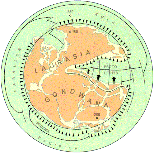
The above map of Pangaea is typical. It is from [1]. To better see how the Earth's continental crust fitted together when it was part of PreEarth, consider these diagrams of PreEarth, drawn from the perspective of space. 
The inner circle shows the area where TheOldMoon struck PreEarth. The crust within this circle was obliterated by the impact. Of course, the seas and oceans belong to Earth, not PreEarth. They are marked only to establish where todays continental crust was, when it was part of PreEarth. 
In the reconstruction, I have reassembled the continents in, more or less, the standard way, with Gondwanaland stitched together as illustrated below: 
This map is also from [1]. The animation below, provides a three dimensional view of PreEarth. The region within the circle was that obliterated by the impact. 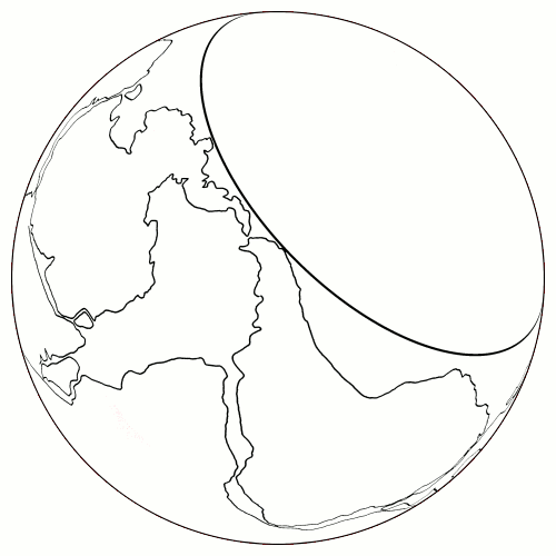
In composing the pictures and animations, I was eventually forced to confront the problems of the tectonic development of Central America, the northern polar region, the East Indies and the Mediterranean. I developed crude, but basically correct, formulations for two of these, before finding that S. Warren Carey had solved all of this, in detail, decades ago [2]. Also, in drawing the animations of the expansion, I used a radius of PreEarth (and thus TheOldMoon) that was too small. PreEarth can, in fact, be given a wide range of radii, while still keeping the continents their correct size, by incorporating the extra area in the impact zone, and this can be done without it greatly effecting the illustrated continental reconstruction. However, redrawing these diagrams is a big task, one that I presently have no time for. In this print version, the animations have been represented by their first frame. Continental Drift. When TheOldMoon impacted PreEarth, TheOldMoon obliterated nearly half of PreEarth's crust. The impact punched a relatively round hole in the crust and TheOldMoon disappeared into PreEarth's now fiery interior. PreEarth's volume almost doubled and PreEarth quickly expanded to form our Earth, much as we now know it. One of the most visible results of the collision were the impact mountains. These are the North American coastal ranges, the Andes, the Antarctic Peninsula mountains and various ranges along the Western Pacific, some of which have been physically detached from mainland Asia. In the following diagram, the extent of these ranges has been marked in blue.  Since creating the above graphic, I have discovered a remarkable reconstruction of the south-west Pacific, by S. Warren Carey [2], in which he has Papua-New Guinea running almost north to south and exactly where it should be, for its ranges to be included among the impact mountains of the collision. This, together with the Southern Alps of New Zealand and Carey's reconstruction of the north-west Pacific, completes the circle of impact mountains, which are then seen to have initially formed a complete ring. The collision caused PreEarth's surface area to expand by some sixty percent, resulting in the surviving crust fracturing into many pieces. Since the radial (vertical) forces generated by the expansion, were very much larger than any tangential (horizontal) forces, these pieces were then expanded apart. The energy needed to move these massive blocks of continental crust horizontally, over any base, whether molten or not, was so large, that they did not move across the surface at all, but stayed in place while molten material flowed into the spaces between them, separating them, and giving the appearance of their movement across the globe of the Earth. Thus, continental drift was not the continents physically moving over the surface of Earth, as claimed by current theories, but the continents standing still, at their original positions on the surface, while the spaces between them expanded. An important consequence of this is that once a gap opened between two sections of continental crust, there was no way of removing it. Hence, it became a permanent feature of the new landscape. The most spectacular example of this was the opening of the Atlantic. Here, PreEarth's crust was split from top to bottom and expanded to form the Atlantic basin. The following animation, illustrates its evolution.  The increasing volume below PreEarth's continental crust cracked it from within. As the planet expanded, molten material flowed into the cracks, widening them, and thus the continents were expanded apart. The molten material quickly solidified as the oceans flowed over it. The expansion of these cracks only ended when PreEarth had expanded to its full size, that is, when it had reached the size of the Earth. The Indian and Atlantic basins are both such expansion features. The Pacific basin is also, partially, an expansion feature (in the south and south-east). The expansion opened up tension cracks and fissures that filled with huge quantities of magma. Such intrusions are often measured in cubic kilometers. The dykes that cut through sections of crust are often thick, and on occasions, so numerous, that they are said to swarm. These are expansion features. These features often occur simultaneously with mountain building that is frequently claimed to result from crustal compression. But how can these intrusions intrude, if the crust is being compressed? How can the magma find its way into cracks and fissures, if the cracks and fissures have been sealed off by crustal compression?  The above picture has many features that are problematic for the current theory of continental drift. For example; How can Africa be drifting east, away from the mid-Atlantic ridge, and west, away from the Indian mid-ocean ridge, at the same time? How is it that Africa is also drifting north, away from the Antarctic mid-ocean ridge in the south? Where are the subduction zones? Why are the only subduction zones found in the Mediterranean, which is to the north? How does all this spreading, east and west, end up being subducted in the north? And, why is the region of subduction zones so small, in comparison to the region of spreading ridges? The Antarctic continent is an even more extreme example of these problems. I will not dwell on the many problems of the current theory of continental drift, but wish to point out, that the reason the African plate appears to have expanded around continental Africa, and the reason that the Antarctic plate appears to have expanded around Antarctica, is probably because they did. To try and explain why certain topological features, such as mountain ranges, formed where they did, we need to know more about the spins of TheOldMoon and PreEarth. In particular, we need the locations of their rotational poles. The global positioning system (GPS), is a constellation of twenty four satellites which is used for navigation and precise geodetic position measurements. Daily position estimates of various locations have been taken and their horizontal movement (relative to the satellites) recorded. This data is summarized in the map found on the following web-page: http://sideshow.jpl.nasa.gov/mbh/series.html A surprising feature of this map, is that it reveals distinct rotations around two poles. One pole located in the west Pacific and the other in the Indian Ocean. Here is the map with the centers of rotation marked by large red dots: 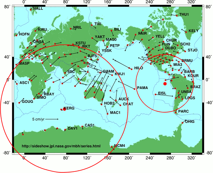 I suspected that these rotations were fossilized evidence of PreEarth's poles. So, using only conformal (angle-preserving) transformations, I transfered the above vector field to a flat map of PreEarth (using the plane chart projection). The poles then appeared in Antarctica and northern South America (where these regions are considered as areas of PreEarth). These poles were not antipodal. Here is the map with the latitudes, relative to the South American pole, marked in ten degree intervals:  This gave a good fit for the North American rotation, but a poor fit most everywhere else. The antipode is located near South China/Papua New Guinea. Here is a map with latitudes, relative to the Antarctic pole, marked in ten degree intervals.  This gave a good fit for Eurasia and Africa, but a poor fit elsewhere. The antipode is in northern Canada. Remember, the named regions define areas of PreEarth. Although it is possible to have non-antipodal rotational poles, for example, the Moon, to have them offset by such a distance, seems impossible. After much thought, I came to the conclusion that the North American rotation was the last remnants of PreEarth's original spin (which was initially, north-south, relative to todays spin). However, the Antarctic rotation appears to have been imprinted upon the greater part of PreEarth's crust, by TheOldMoon's spin, during the impact. TheOldMoon's spin, was roughly east-west. With the amalgamation of the two planets, their spins rapidly combined to give today's spin, with TheOldMoon's spin clearly predominating. The Earth's current topography is almost entirely a result of the collision (the initial impact, the expansion and the mixing of spins). Before the collision, PreEarth was level. The heat generated by the collision (at least partially) melted the mantles and cores of both planets, which then quickly combined to become the mantle and core of the Earth. However, the massive blocks of PreEarth's crust (that is, the Earth's continental crust) were still solid to a depth of some tens of kilometers. Rather than being crushed and melted by resisting the impact forces, these blocks of crust just went with the flow and although their surface material was severely broken and contorted, these blocks ended up relatively intact. These giant pieces of the ancient crust, acted like a thermal blanket, protecting life from the heat below. The continental crust is some twenty to eighty kilometers thick and is a poor conductor of heat. Consequently, it would take a very long time for the underlying heat to reach the surface by conduction alone. Thus, the continental crust provided shelter for the life living upon it. Although the sea-floor was initially molten, the oceans quickly cooled the exposed magma and formed an oceanic crust. Once solid, this crust was also an efficient thermal barrier. This reduced the flow of heat to the oceans until it was no longer a threat to the life within them. The hot-spots in the oceans cooled by convection and the oceans cooled by evaporation. The evaporation produced massive storm systems which eventually cooled by radiating their energy to space. Some of these storms reached the polar regions, where they dumped their water as snow and thus built up the ice-sheets of the ice age. When TheOldMoon impacted PreEarth, its north to south spin (relative to today's spin) was blocked. This led to the formation of the Rockies, the East Siberian ranges and the Appalachians. PreEarth was initially level and covered in thick horizontal layers of loosely consolidated material (how these layers originated is an interesting question). The sudden deacceleration of the mantle underlying these layers, caused them to slide horizontally until they ended up, broken and torn, in huge piles, that we now call mountains. Much of the rotational energy of PreEarth was expended in such mountain building. The following graphic illustrates how the blocking of PreEarth's spin led to the rise of the Rockies and the East Siberian ranges.  The Appalachians were a secondary accumulation of folds in the carpet, so to speak. PreEarth's north-south spin plucked the Aleutian island arc off the main continental block and expanded it south, with the region between them filling with magma.  While the rotational energy of PreEarth was being expended in mountain building and further melting of the mantle, TheOldMoon's spinning mass was beginning to grip PreEarth's continental crust, accelerating it, west to east. Since the direction of the collision was offset from the line joining the centers of the planets, most of the expansion occurred in the (Earth's) southern hemisphere, as can be seen from the following animation. Thus, TheOldMoon's spin gripped the south first, accelerating it faster than the north, creating massive strains, that were released by mountain building.  The acceleration of the southern regions of Earth, relative to the northern, ripped the whole southern hemisphere hundreds of miles to the east of its northern counterpart, forming vast mountainous regions, including the Alps and Himalayas. The eastern movement of Africa, with respect to Europe, transported Spain from above Tunisia to its present position. The eastern movement of South America was responsible for the confused area in the West Indies. The eastern movement of Australia was responsible for the confused area in the East Indies. This was the massive planet wide shear described by S. Warren Carey [2]. Suppose, PreEarth had a radius of 5200 km (see below) and that we mark a circle of diameter 1126.8 kms on its surface. Then this would enclose an area of about one million square kms. If we mark the same circle on the Earth's surface, then it would enclose only 999,014 square kms, a decrease of 986 square kms. The difference is due to the curvature of a sphere decreasing as its radius increases. Now, if this circular area of PreEarth's surface was prevented from expanding laterally by being part of a large block of continental crust, then the fact that less surface area will fit in the same circle on the Earth's surface, means that the original surface must buckle and/or tear, as it makes the transition to being a part of the surface of the Earth. Of course, we are talking about the buckling and tearing of slabs of crust tens of kilometers thick. The forces produced by this adjustment in curvature, may not in themselves have been large enough to crack the slabs, but would contribute to, and accentuate, other forces that were. In particular, it will have contributed to the mountain building of the spin induced global shear.  The Mediterranean Sea marks where the Europe-Africa section of the crust buckled under the strain of the differing spins. Relative to Europe, Africa moved hundreds of kilometers east. Spain and Italy, being trapped between these massive blocks, were not only moved laterally, but also rotated (counterclockwise). Warren Carey predicted these (and many other) rotations from his theory of oroclines, sphenochasms and such. His predictions were later confirmed by studies of the paleomagnetic record of the areas concerned. Eventually, the northern hemisphere was accelerated to the speed of the southern hemisphere and the mountain building related to the global shear, ceased.  In the western Pacific, the underlying east-west spin of TheOldMoon plucked large blocks of continental crust from the Asian mainland. These were then expanded hundreds of kilometers east of their original position. For example, in the northwest, a whole section of the impact mountains was detached from the mainland and left as the mountainous islands of Japan. These blocks plucked off Asia were forced (by PreEarth's spin) into the Pacific oceanic crust, faster than the planet was expanding. With their eastward path blocked, they attempted to ride over the oceanic crust and in the process forced the oceanic crust downward, sometime many kilometers. In this way, the deep trenches of the west Pacific, such as the Mariana Trench, were formed. Determining Their Size. In calculating the sizes of TheOldMoon and PreEarth, it is assumed that the impacted area was circular and that the original surface of PreEarth, not directly impacted by the collision, still exists as an area of continental crust somewhere on Earth, so that, when all the continental crust is gathered, it will complete the non-impacted area of PreEarth. First, let us estimate the area of PreEarth's surface destroyed by the impact. Let u be the radius of PreEarth and v the radius of TheOldMoon. The impacted region is a surface of revolution of the circle g(x)= √u2 - x 2 between the planes x = √u2 - v 2 , and x = u. This area is given by the formula;
We take the present land area, plus the area of continental shelf, as our estimate of the area of PreEarth's crust that survived the impact. The land area of Earth is 148,169,000 km2. The continental shelf occupies another 30,000,000 km2. So, we have the following lower bound for the surface area of PreEarth; Surface Area of PreEarth = 4πu2 ≥ 178,169,000 + A where A is the impacted area referred to above. Rearranging, we have the first equation; (Equation 1) 2πu2 + 2πu(√u2 - v 2) = 178,169,000 km2 (Equation 2) 4/3 π(u3 + v3) = 1,086,230,340,743 km3 The second equation results from the fact that the volumes of PreEarth and TheOldMoon must add to give the volume of the Earth. I solved these equations for u and v, to obtain; u = Minimum Radius of PreEarth = 5075 km v = Maximum Radius of TheOldMoon = 5050 km Implicit in this calculation is the assumption that the average temperatures of PreEarth and TheOldMoon were similar to the Earth's (since the volume of a given mass depends on temperature). This, of course, would not have been true, as the impact would have generated immense heat. In order to take this into account, I tried to find coefficients of thermal expansitivity for the various materials of the earth, ranging from surface temperatures and pressures, to those at the center of the Earth. However, it proved impossible to find a model that I had any confidence in. So, one should keep in mind that these radii may need to be adjusted slightly for temperature changes. After much consideration, I chose to work with a radius of 5200 km for PreEarth and around 4800 km for TheOldMoon. The Magnetic Fields. When the planets collided, obviously their outer layers impacted first. Thus, the outer layers sustained a large change in angular momentum, as their spins clashed. However, this change in angular momentum was not transmitted, in full, to lower layers, as there was slippage at layer boundaries. In particular, the mantle-core boundary would have been prone to such slippage. So, in the first moments of the collision, the mantles would have been slowed relative to the cores. The fusion of the cores would not change this, and thus, the Earth acquired a core that rotated faster than its mantle. This faster rotation of the core is probably the source of Earth's relatively strong magnetic field. That the Earth's core is indeed rotating faster than the mantle, has been reported by Richards and Song and others [3]. Their research found that the inner core spins about a half a degree, per year, further than the mantle. This implies that each year, the inner core advances twenty kilometers further than the mantle above it. This differential rotation, is very difficult to explain with current theories, however, it is a natural consequence of the proposed planetary collision. As the two metallic cores fused, their combined magnetic field must have been in a state of extreme flux. The planetary fusion probably took less than a day and many reversals of magnetic polarity must have been experienced within this period. These reversals were recorded on the expanding sea floors, as distinctive stripped patterns of magnetism. Clearly, for these rocks to have recorded this swiftly changing magnetic field, they must have cooled to below their Curie temperature, very rapidly. This rapid cooling was due to the new lava being immersed in the water of the oceans. This cooling, was not just a surface effect, as cracks and faults allowed the water to percolate to great depths. As water cools the surface of a molten lava, a thin crust rapidly forms. The large temperature gradient between the crust and the molten lava, creates tensional stresses that crack the crust, and allow water to percolate through these cracks to come in contact with more molten lava and form another crust, which then cracks,... and the cycle of crust formation and cracking continues. In this fashion, it is hypothesized that water can rapidly cool large volumes of lava to below the Curie temperature (which is about 500 degrees centigrade for basalt). Such rapid cooling produces thick layers of pillow basalts. Seismology shows that the oceanic crust typically consists of four layers, a layer of sediment, the layer of pillow basalts (400-600 meters thick), a layer sheeted dikes (1500 meters thick) and a layer of gabbro (6000 meters thick) that extends down to the mantle. Of course, the layer of sediment is not initially present. Information regarding the magnetic signature of a section of sea-floor is obtained by towing a magnetometer (behind a ship) over the area and recording the total magnetic field. The magnetic anomaly is obtained from this by subtracting out the various contributions of the current magnetic field. It is the magnetic anomaly that records the reversals of magnetic polarity. It is a curious fact, that the magnetic anomaly originates mainly from the layer of pillow basalts and almost entirely from the pillow basalts and the sheeted dikes, combined. The gabbro layer, even with its great thickness, hardly contributes to the signature. More detailed information can be obtained by drilling into the sea floor and testing the resulting cores in laboratories. However, drilling into basalt is a difficult and expensive operation and few drill-holes have penetrated far into it (the maximum appears to be 1800 meters of oceanic basement for hole 504B of the Deep Sea Drilling Project). Since basalt and gabbro are completely crystallized at temperatures above 900 degrees centigrade, the magnetic mineral grains (typically titanomagnetite) are not physically rotated to align with the prevailing field, but the growth of magnetic domains in the direction of the applied field, records the fields past orientation. This record is called a thermal remnant magnetization. It is the magnetism acquired during initial cooling and is the main source of magnetism in these layers. Laboratory tests of such cores, indicate that the average field strength of the thermal remnant magnetism of the pillow basalts and sheeted dikes, are about, 10 A/m and 1 A/m, respectively. 
Although no one has drilled down to the gabbro layer to check, its thermal remnant magnetism is assumed to be low (less than 1 A/m). One can see why this is believed, as follows; If one assumes a sea-floor spreading of 32 mm/year, then as the plate moves away from the spreading ridge, the positive and negative reversals would be juxtaposed in dipping vertical layers, as in the above diagram, so if the gabbro layer contributes to the anomaly in any significant way, then this superposition would smear the pattern observed by a ship, which is not the case [12]. So, how is it that the gabbro layer does not contribute significantly to the magnetic anomaly? How exactly did the six kilometer thick gabbro layer lose its thermal remnant magnetism and lose it over vast areas of ocean basin, while the pillow basalts retained theirs? How is it, that essentially the same lava has recorded, and kept, a significant record in the pillow basalts, yet not recorded, or lost, this record, when it solidified as gabbro? Of course, one possibility is that the gabbro layer actually has a significant magnetic signature, but that it is aligned with the Earth's current magnetic field. This is what one would expect from the rapid expansion caused by the collision. The rapidly cooled upper layers, in particular, the pillow basalts, would exhibit a magnetic signature showing a typical stripped pattern of reversals, as it recorded the instability of the magnetic field during the period when the cores amalgamated. However, lower layers, in particular, the gabbro layer, would solidify long after the magnetic field had stabilized and would thus be imprinted with the Earth's current magnetic field and be lost from the calculations of the magnetic anomaly, when the current magnetic field and its induced fields are explicitly subtracted out. Evidence for rapid cycles of magnetic reversals has been found by Coe and Prevot [4,5], who found a thin lava layer that must have cooled within fifteen days, yet had ninety degrees of reversal recorded continuously in it. That is, they found a continuous record in the lava, of the Earth's magnetic field moving from the pole to the equator, in less than fifteen days. In 1995, they reported an even faster reversal. If one has reversals in days, then why not in minutes? Even though the inner core is spinning in the liquid of the outer core, the motion will still be accompanied by friction and this friction will gradually slow it. Consequently, one expects the magnetic field to be decaying. Apparently, this is the case. The Earth's magnetic field has been measured to be decaying at about five percent per century [6]. With current ideas, this is not a cause for concern, as it is expected that the field, upon becoming weak, will reverse and recover its strength. However, if reversals were a one time occurrence, then mankind may be facing a particularly serious problem, within the next couple of thousand years. Wouldn't the Impact Melt the Planets? The gravitational binding energy of a planet, U, is the energy released by the assembly of the planet from atoms which were originally an infinite distance away. Or, alternatively, it is the energy needed to disassemble the planet into atoms by moving each an infinite distance away. If the planet is spherical, with uniform density, one can establish a simple formula for the binding energy, by imagining that the planet was constructed by bringing an infinite number of infinitesimally thin spherical shells of mass from infinity and adding them to its surface. This formula is given by, U = 0.6GM2/R, where G=6.67428 x 10⁻²⁰ km3/(kg s2) is the gravitational constant, M kg is the mass of the planet and R km, is its radius. U is measured in megajoules, MJ. One calculates the binding energy of Earth, to be approximately 22.40492 x 1025 MJ. However, the Earth is far from a sphere of uniform density. To obtain a more accurate estimate of the binding energy, I adopted the Preliminary Reference Earth Model (PREM) of Anderson and Dziewonski [7]. The PREM model provides a density profile of the Earth's inner structure. This density profile is traced by the magenta curve in the graph on the following page: From the density, one calculates the mass, pressure, gravity and binding energy functions, which have also been plotted. The mass at a radius r, is the mass within the sphere of radius r. The binding energy at r, is the energy required to disassemble the part of the planet within the sphere of radius r. Similarly, the gravity at r, is the attracting force of the planet within the sphere of radius r. In each of these cases, the mass above this sphere is ignored. The pressure at a radius r, is the downward force exerted by the weight of the planet above that radius, per square meter. 
The density and gravity functions, use the left scale. The mass, pressure and binding energy, use the right. The mass scale is x 1024 kg, the pressure is x 1011 Pascals, the binding energy is x 1026 MJ, gravity is in m/s2 and the density is in g/cm3. The PREM model of the Earth provides the following numbers: Binding Energy = 24.84608 x 1025 MJ Pressure at center of Earth = 363.65 GP Surface Gravity = 9.8129 m/s2 Radius = 6371 For whatever reason, the PREM model gave a slightly lower estimate of the Earth's accepted total mass of 5.97369e+24 kg I constructed models of TheOldMoon and PreEarth, where PreEarth ranged from containing all of Earth's core, to containing none of it. One model of interest, although not pursued here, has TheOldMoon with five percent of the Earth's core. In this model we make the assumption that the Earth's inner core was originally TheOldMoon's core and that Earth's outer core was originally PreEarth's core. If we assume that both TheOldMoon and PreEarth have had similar histories since formation, then they would have had a similar, core iron to silicate rock, ratio. This requirement necessitates PreEarth having had fifty eight percent of Earth's core and TheOldMoon, forty two percent. Naturally, this model is called the 58% model. Initially, I assumed a cold density profile for both planets, but later warmed to a history of TheOldMoon that inferred a higher temperature profile and consequently constructed a density profile, the hot density profile, consistent with the higher temperatures. The models have pure iron cores with density appropriate to the given temperatures and pressures. In the cold density profiles the silicate rock region immediately above the core is modeled on fayalite, with twenty percent of the iron replaced by magnesium (fosterite with eighty percent of the magnesium replaced by iron), that is, (Fe0.8 Mg0.2 )2 SiO4 . This gives a maximum silicate rock density of 6.9 g/cm3. The density is then assumed to decrease linearly to 3.4 g/cm3 at the surface. In the hot density profile the silicate rock region is assumed to be more like Earth's. The cold density profile for PreEarth assumes a uniform temperature of 300° K. 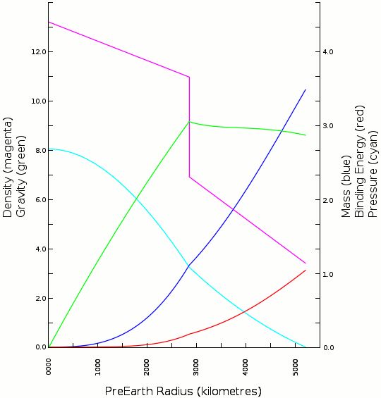
The cold density profile for PreEarth gives the following numbers: Total Mass = 3.48280 x 1024 kg Core Mass = 1.10624 x 1024 kg Binding Energy = 10.37876 x 1025 MJ Pressure at center of PreEarth = 268 GP Surface Gravity = 8.5966 m/s2 Radius = 5200 The cold density profile for TheOldMoon assumes a uniform temperature of 300° K. 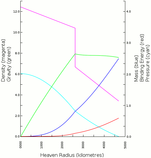
The cold profile for TheOldMoon, graphed above, gives the following numbers: Total Mass = 2.48456 x 1024 kg Core Mass = 0.80058 x 1024 kg Binding Energy = 5.84173 x 1025 MJ Pressure at center of TheOldMoon = 200 GP Surface Gravity = 7.5712 m/s2 Radius = 4680 The hot density profile for TheOldMoon has a temperature gradient from 4000° K at the center, to 300° K at the surface. It is assumed that TheOldMoon was engaged in multiple collisions before finally colliding with Earth and that these collisions led to the assumed temperature gradient. 
The hot profile for TheOldMoon graphed above, gives the following numbers: Total Mass = 2.48456 x 1024 kg Core Mass = 0.80058 x 1024 kg Binding Energy = 5.55427 x 1025 MJ Pressure at center of TheOldMoon = 168 GP Surface Gravity = 6.8658 m/s2 Radius = 4921 In what follows, I use the hot profile for TheOldMoon. The seemingly insurmountable problem of determining the energy involved in the formation of Earth, immediately after the collision, has a surprisingly simple solution. The idea is to take PreEarth and TheOldMoon at the point of first contact, that is, when they are just 10,121 kilometers apart, dissemble them to infinity, then bring everything back from infinity and assemble Earth. The energy necessary to separate PreEarth and TheOldMoon to infinity, is: G MP MH / 10121 = 5.70637 x 1025 MJ, The energy necessary to dissemble PreEarth and TheOldMoon, is: Binding Energy(PreEarth) + Binding Energy(TheOldMoon) = 15.93303 x 1025 MJ The energy provided by the assembly of Earth, is: Binding Energy(Earth) = 24.84608 x 1025 MJ So, the energy released from the point of contact through the formation of the Earth, is: Energy Released = (24.84608 - 15.93303 - 5.70637) x 1025 = 3.20668 x 1025 MJ This therefore, is the minimum energy that will be released during any collision. It is the energy released in the reforming of PreEarth and TheOldMoon into the Earth. Of course, this does not incorporate any kinetic energy that the two original planets may have had. This just involves placing PreEarth next to TheOldMoon and letting gravity transform them into the Earth. But, this is already 5.368 megajoules per kilogram. Assuming an average specific heat of 1330 J/kg°K, this amounts to a 4036 degree rise in the temperature of the entire Earth. The same calculation for the cold profile for TheOldMoon determines a 3500 degree rise. It proved impossible to accurately determine the average specific heat of the Earth. The following estimates are essentially educated guesses. For the inner and outer core, I adopted the values, 728 and 815 J/kg°K, respectively, found in [8]. A lower bound for the specific heat of mantle rock, can be found from the classical Dulong-Petit (high temperature) limit of 3R Joules per mole (R is the universal gas constant), which for silicate rocks is about 1200 J/kg°K [9]. 
Above, are plotted the specific heats of various minerals as a function of temperature. Fosterite (Mg2SiO4) is traced in green, fosterite (β-phase structure) in magenta, fosterite (spinel structure) in mauve, pyroxene (MgSiO3) in blue, perovskite (MgSiO3) in cyan, magnesiowüstite (MgO) in orange and stishovite (SiO2) in red [10]. The above minerals, with about ten percent of the magnesium replaced by iron, are thought to be the major components of the mantle. The presence of the iron reduces the specific heats by some five to ten percent. The major components of the lower mantle are thought to be perovskite and magnesiowüstite, with about ten percent of the magnesium replaced by iron, and stishovite. The temperature of the lower mantle is thought to vary from about 2000 to 3800 degrees Kelvin, although both of these could be somewhat higher. Taking all this into consideration, I chose a specific heat of 1500 J/kg°K for the lower mantle. Some seventy to eighty percent of the upper mantle is olivine (fosterite with ten percent iron) and orthopyroxene (pyroxene with ten percent iron), with the remainder being mainly clinopyroxene and garnet. Since the upper mantle would have been molten for some time, we have to consider the specific heat of magma. Volcanologists have a formula [9] which gives the specific heat as a function of the magma's component oxides. If one uses their formula to calculate the specific heat of a magma having the proportion of oxides believed to constitute the mantle, one obtains the value of 1758 J/kg°K. Taking these things into account, I chose a specific heat of 1600 J/kg°K for the upper mantle. So, now we have estimates of the specific heat for the upper and lower mantle and the inner and outer core. Integrating these values over the Earth's mass, one obtains the average value of 1330 J/kg°K, stated above. Now, given that just placing PreEarth next to TheOldMoon and letting gravity transform them into the Earth, raises the temperature of the Earth by some 4000 degrees, the relative velocity of PreEarth and TheOldMoon, before the collision, must have been very small. But how could this be? Suppose, initially, that neither planet had extensive oceans and that TheOldMoon was in a synchronous orbit about PreEarth. Suppose, that a large icy comet encroached within PreEarth's Roche limit, broke up, and dumped billions of cubic kms of ice on the planet. This new mass of water would cause adjustments to TheOldMoon's orbit, leaving its period slightly shorter than PreEarth's day. Thus, the oceanic tidal bulge would lag behind TheOldMoon and act to decelerate it in its orbit. TheOldMoon would then slowly spiral towards, and finally impact, PreEarth. This scenario was chosen, because, as TheOldMoon approaches PreEarth, fully half the kinetic energy that TheOldMoon would have otherwise accrued, will be dissipated by tidal friction. The kinetic energy of TheOldMoon, just moments before impact, that is, when the planet centers were 9880 kms apart, would have been, Kinetic Energy(TheOldMoon) = G MP MH / (2 x 9880) = 2.9228 x 1025 MJ. If this entire quantity was absorbed during the collision, then Earth would experience a 3682 degree temperature rise, giving a total rise of 3500 + 3682 = 7182. This is a big rise, but it is verging upon the realm of the possible. We can improve upon this by giving PreEarth a moon which is impacted by TheOldMoon at the very time it is clipping the treetops of PreEarth. In this intermediate collision, we suppose that TheOldMoon loses much of its energy as it deflects the moon into a higher orbit. If, TheOldMoon loses half its kinetic energy, then the total temperature rise for Earth will be only 3500 + 1841 = 5341 degrees. And this is quite possible. I am not claiming that the above scenario happened, or is even likely, just that it demonstrates that the collision hypothesis cannot be automatically discarded on thermodynamic grounds alone. Other scenarios are possible. Suppose, a catastrophic collision between TheOldMoon and a large object, blasted TheOldMoon's entire silicate rock layer into an extensive debris field, leaving its iron core as the largest remnant. Further collisions with the debris would lead to the rump iron core gathering a new mantle and cascading ever closer to PreEarth. Suppose, further, that one final impact with the debris precipitates the collision with PreEarth. Then, this is likely another "low" temperature collision. The hot density profile for TheOldMoon was modeled for this scenario, but there were too many variables to derive any meaningful numbers. In this scenario, TheOldMoon would not necessarily be excessively hot before impacting PreEarth. After the initial collision, the iron core, being metallic and without its silicate rock blanket, would cool rapidly. The silicate rock remnants, being smaller, would also cool quickly. Further impacts would be smaller and between objects having a common vector to their velocity, so they would generally be less violent, surface events, and the heat generated by them would be lost to space over the long lengths of time involved. The debris field beyond TheOldMoon's reach, would also accumulate, creating a new satellite of low density, poor in volatiles, and lacking an iron core, namely, the Moon as we know it today. Radiogenic Dating. K40 is a radioactive isotope of potassium which decays to argon, Ar40 and calcium, Ca40. If one measures the ratio of K40 to Ar40 in a rock sample, one can estimate the date that the rock was last significantly heated. It is an assumption of the dating method, that when the rock sample was last heated, all of the existing argon gas was able to escape. This resets the potassium-argon clock to zero and is necessary if the dating method is to provide accurate results. However, in many instances, this assumption is known to be false, see for example, [11]. In particular, when TheOldMoon impacted PreEarth, much (probably most) of the argon gas, would not have had the time, nor the opportunity, to escape from the molten materials that formed. Not, at least, until long after the two planets had coalesced into the Earth. Suppose, TheOldMoon was involved in the catastrophic collision mentioned above, in which the entire silicate rock layer was exploded away from the planet. Then, the impact would have melted and scattered the silicate rock, causing it to lose most of its Ar40 into space. As the rump iron core of TheOldMoon reconstituted its mantle by gathering these Ar40 depleted rocks in further collisions, it is clear that even more argon would have been lost and that TheOldMoon's new mantle would have almost no Ar40, while PreEarth's mantle would still have its full complement. So, when TheOldMoon impacted PreEarth, we would expect to find argon gradients depending on the degree of mixing of their mantles. That is, there should be argon gradients between areas where the Earth's mantle was a well-mixed combination of TheOldMoon and PreEarth's mantles and areas where it wasn't. As an example of this, in the expansion of the oceans we would expect that the oceanic crust of the continental margins would be mainly from PreEarth's mantle, with little of TheOldMoon's mantle mixed in. Thus the continental margins would be richer in argon and have a greater apparent age. As we proceed further from the continents we would expect the material forming the oceanic crust to have a progressively larger percentage of TheOldMoon's mantle mixed in, and thus, to date progressively younger. So, the argon gradient used to date the sea-floor, can be interpreted as a geochemical gradient, one which can be explained by the mixing of materials with different initial argon concentrations. Anyway, if the Atlantic opened in a matter of hours, then clearly the usual methods of dating the sea floor are well off the mark. This mixing of mantles may also explain another (otherwise difficult to explain) feature. Volcanism at the continental margins brings up acidic rock, while at the mid-oceans ridges, it brings up ultrabasic rock. Thus it would appear, that PreEarth's mantle was more like the acidic rock of the continental margins and TheOldMoon's mantle was more like ultrabasic rock. Note, that the absence of magnetic reversals with potassium-argon dates older than 160 million years (the initial breakup of Pangea) is evidence that reversals are tied to the breakup of Pangea, that is, with the collision of TheOldMoon and PreEarth. Note also, that the venting of argon into space and its eventual capture by Earth's gravity, might explain the anomalously high levels of argon-40 in the atmosphere. Gravity Greater than Previous. The collision between TheOldMoon and PreEarth had the potential to change the surface gravity to such an extent that very little life would survive. The model where PreEarth has no iron shows that its surface gravity would have been 6.16 m/s2 . After the impact, the surface gravity would have increased by sixty percent. One suspects that such a drastic change would have extinguished all life. It is certainly difficult to imagine any animal life adapting to such an increase. At the other extreme, in the model where PreEarth had all the iron, the surface gravity would have been 9.78 m/s2, which is about the same as Earth's today. In the 58% model, PreEarth would have had a surface gravity of 8.6 m/s2, so plants and animals would have had to adapt to a fourteen percent increase. Certainly, large animals would have had difficulty adapting. Such an increase, may have been responsible for the disappearance of the dinosaurs, and other large animals and plants. However, many of the smaller animals and plants would have been able to survive this. There is a large amount of indirect evidence that the Earth's gravity is now greater than it once was. For example, pterosaurs, such as hatzegopteryx, had wingspans of over thirteen meters and large, solidly constructed heads, making it a great puzzle as to how they flew, or even if they flew. Similarly, it is not known why the larger dinosaurs such as, argentinasaurus, did not collapse under their own weight. It is also unknown, how the gigantic bird, argentavis magnificens, with a mass of seventy kilograms and a wingspan of seven meters, managed to fly, when an albatross, with a mass of only nine kilograms and a wingspan of three meters, finds it difficult to get off the ground. Of course, if gravity was once significantly less, then maybe this can be explained. The Global Clay Layer. The world has been covered in layer of very fine particles (less than two micrometres) called clay. Clays result when granite is ground into powder and weathered. When TheOldMoon struck PreEarth, billions of tonnes of continental crust, in particular, granite, was blown into orbit. The finest particles precipitated from the atmosphere last, forming the clay layer. This explains the global distribution of clay and why there is generally a clay layer on, or close to, the surface. Of course, such huge quantities of dust in the atmosphere would have eventually led to global cooling and an ice age. The Ice Age. The ice-caps of the ice age, contained a massive volume of water. As the ice-caps formed, sea-levels dropped by some 200 meters. The evaporation of such a quantity of water, would have required an immense amount of heat. In certain regions, temperatures needed to be sufficiently hot to supply the necessary evaporation, yet in certain other regions, they needed to be sufficiently cold to enable a buildup of ice. And, of course, this temperature differential had to be maintained in the face of masses of warm moist air being transported to the colder region. All currently accepted theories fail to provide a plausible mechanism by which this temperature differential can be maintained. The impact hypothesis, however, has such a mechanism, built in. With large areas of the oceans being heated from below, huge volumes of water entered the atmosphere. Strong weather systems carried the warm humid air towards the polar regions, where cooler temperatures precipitated snow. In this way, large ice sheets were built up. While the ocean and atmosphere over the mid-oceanic ridges were hot, the poles would have remained cold. The insulating effect of the continental and oceanic crust, kept the flow of heat from the mantle to the surface, much lower than the flow of heat from the surface into space. This meant that the immense amounts of dust blown into orbit by the impact, kept the poles (and, in fact, the whole Earth) cold for thousands of years. So, paradoxically, rather than melt the Earth, the impact led to the an overall cooling of the planet and this allowed the ice-sheets to form. Last Say. The content of this paper was first presented in a public lecture, on November 2, 2008, at the Alexandra Park Raceway, Auckland, New Zealand. The next day, I outlined the main ideas to various members of Auckland University's geophysics department and asked if they would like to hear the entire lecture. Their answer was a stunning, "No,..." with an eventual "Why don't you write it up?" I did not bother to mention that I had already been writing up these ideas for a long time, and that it would be a further long time before this was complete. This experience did however, emphasize to me the need for a compelling, easily digested, visual presentation, as clearly, the academic community was not going to tax its mind to see if there was any truth in what I was saying. I learned to program in the language C (a particularly bad choice), to use graphics software and spent nearly a year ironing out various details of the presentation and fashioning the maps and the other graphics presented here. Over this period, the details of some of the maps changed and should eventually be updated. However, since updating these would require a large effort (and there is no guarantee that more changes will not be required) they are presented as imagined at their time of creation. The work presented here was completed in October, 2009. I had planned to revisit certain sections before publishing, but the recent "borrowing" of a copy of my manuscript, has convinced me to publish the work, as is, without the desired revisions, or the much longer second volume. The idea that the Earth was the child of a giant collision, first occurred to me sometime in 1996 while looking for terrestrial impact craters on a wall map of the Earth. The second volume of this work, also outlined in the public lecture, is still being written. Website: http://preearth.net ; Email: preearth7@yahoo.com ; 20 April 2010. References. [1] De Wit, M., Jeffery, M., Bergh, H., and Nicolaysen, L., "Geological map of sectors of Gondwana reconstructed to their disposition ~150 Ma. America Association of Petroleum Geologists", 1988. [2] Carey, S. Warren, "A tectonic approach to Continental Drift", in "Continental Drift: a symposium", editor Carey, S. Warren, 1958. [3] X. Song and P. G. Richards, "Seismological evidence for differential rotation of the Earth's inner core", Nature, 382, 221-224, 1996. [4] R.S. Coe and M. Prevot, "Evidence suggesting extremely rapid field variation during a geomagnetic reversal", Earth and Planetary Science 92, 292-298, 1989. [5] R.S. Coe, M. Prevot and P. Camps, "New evidence for extraordinarily rapid change of the geomagnetic field during a reversal, Nature", 374, 687-692, 1995. [6] K.L. McDonald and R.H. Gunst, "An analysis of the earth's magnetic field from 1835 to 1965", ESSA Tech. Report, IER 46-IES 1, U.S. Govt. Printing Office, Washington, 1967. [7] Dziewonski, A. M. and D. L. Anderson "Preliminary References Earth Model", Phys. Earth Planet. Inter., 25, 297-356, 1981. [8] Frank Stacey, "Core properties, physical", in "Encyclopedia of geomagnetism and paleomagnetism", by David Gubbins, Emilio Herrero-Bervera, 2007. [9] A. Navrotsky, "Thermodynamic Properties of Minerals", in "Mineral Physics & Crystallography, Handbook of Physical Constants", T. J. Ahrens, Ed., Amer. Geophys. Union, 18-28, 1995. [10] Fei, Y., H.K. Mao, and B.O. Mysen, "Experimental determination of element partitioning and calculation of phase relations in the MgO-FeO-SiO2 system at high pressure and high temperature", J. Geophys. Res., 96, 2157-2169, 1991. [11] J.F. Evernden, et. al., "K / A Dates and Cenozoic Mannalian Chronology of North America", in American Journal of Science, p. 154, 1964. [12] Gee, J and D. Kent, "Variation in layer 2A thickness and the origin of the central anomaly magnetic high", Geophys. Res., Lett., v. 21, no. 4, 297-300, 1994. Kevin Mansfield, has a BSc(Hons) from the University of Auckland (Auckland, New Zealand) and a PhD in mathematics, from the University of New South Wales (Sydney, Australia). Worlds Collide (PDF version). This page: http://preearth.net/worlds-collide.html | ||||||||||||